Helping drones guide visually impaired people
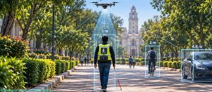
More than 2.2 billion people worldwide live with some form of visual impairment. For many of them, walking down a busy street is stressful, and aids like smart canes can only help them sense what is right in front of them. Drones that fly alongside a person and warn them about obstacles could help. But first, the drone needs to know the distance between the person and the objects around them.
Calculating these distances is harder than it sounds. Small, inexpensive drones usually carry just one camera. Like looking at the world with one eye closed, a single camera cannot easily tell whether an object is both small and close or big and far away. Existing software can turn a camera image into a “depth map” which gives every pixel a score showing how near it is to the rest of the scene. These scores rank objects as nearer or farther but are not distances in meters.
In a study published in ACM Transactions on Cyber-Physical Systems, Yogesh Simmhan and his team at the Department of Computational and Data Sciences, IISc, have developed a method called NeoARCADE that turns these scores into real distances. First, the user stands at a few known distances from the drone; NeoARCADE then reads the user’s depth scores at each spot and works out a simple rule linking the score to distance. The same rule then gives the distance to anything else in the frame, such as a bicycle, a car or passer-by. For each object, it uses the pixel closest to the camera, as the nearest part matters the most. If the lighting or the surroundings change, the system notices that its estimates are drifting, and recalibrates itself.
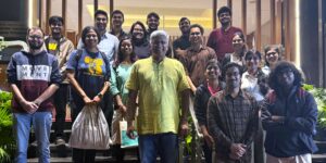
The team led by doctoral student, Suman Raj, tested their technique with a small, off-the-shelf drone following a student posing as a visually impaired person on campus. The computing ran on a small GPU device that fits in a backpack. NeoARCADE estimated the drone’s distance to the person it was following within 25 cm, and to cars and bicycles within 60 cm. By comparison, existing depth map software programs were found to be off by 1.4-2 m.
While the work is still at an early stage, the team hopes the technology will help drones navigate safely in diverse settings, whether to guide visually impaired people around obstacles or survey large areas autonomously.
REFERENCE: Raj S, Madhabhavi BA,Kumar M, Gupta P, Simmhan Y, NeoARCADE: Robust calibration for distance estimation to support assistive drones for the visually impaired, ACM Transactions on Cyber-Physical Systems (2026). https://doi.org/10.1145/3828721
LAB WEBSITE: https://dream-lab.in/



